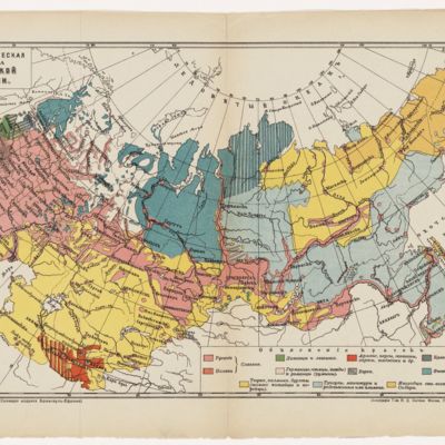
Ethnographic Map of the Russian Empire, 1914
Title
Ethnographic Map of the Russian Empire, 1914
Subject
Rivers and imperial expansion. Rivers and Ethno-linquistic space. Ethno-linguistic map of Imperial Russia
Description
My favorite aspect of this map is its representation of the Russian population that stretches into Siberia and the far east along rivers, depicting Russian colonization. It also reveals various features that were excluded from the map but revealed by the ethnic patterns: such as the steppe/black earth belt (geography/ecology) and the path of the trans Siberian railroad (industrialization, geopolitics)
I think this map could be a useful tool for discussion in an undergraduate section. It presents a great stimulus for conversation even among students with little or no Russian language ability: Can students date it without seeing the date? Where are the Belorussians and Ukrainians (and why are they "missing")? How is it an ethno-linguistic map (and how is it not)? What is the significance of the dots representing the Jewish population? What does the fact that it was published by Ivan Sytin imply about the readership? (discuss the context of increased literacy and reading public). Inorodtsy.
MAP: published in Moscow
Creator
Ivan D. Sytin (1851-1934)
Source
http://beta.hollis.harvard.edu/primo_library/libweb/action/display.do?tabs=detailsTab&ct=display&fn=search&doc=HVD_ALEPH011746453&indx=4&recIds=HVD_ALEPH011746453&recIdxs=3&elementId=3&renderMode=poppedOut&displayMode=full&frbrVersion=&fctN=facet_creationdate&fctN=facet_rtype&fctN=facet_tlevel&dscnt=0&onCampus=false&rfnGrp=3&rfnGrp=2&rfnGrp=1&rfnGrp=show_only&query=any%2Ccontains%2CRussia+maps&scp.scps=scope%3A%28HVD%29&fctV=%5B1910+TO+1930%5D&fctV=Maps&fctV=online_resources&tab=books&dstmp=1409353145815&highlight=true&mode=Basic&search_scope=default_scope&displayField=all&vl(51615747UI0)=any&vl(1UIStartWith0)=contains&rfnGrpCounter=3&vl(freeText0)=Russia%20maps&vid=HVD&institution=HVD
Date
1914
Contributor
Megan K. Duncan Smith
Rights
Harvard Libraries?
Language
Russian
Type
Still Image
Coverage
Imperial Russia, Eurasia
Original Format
printed/published map
Files
Citation
Ivan D. Sytin (1851-1934), “Ethnographic Map of the Russian Empire, 1914,” Mapping Cultural Space Across Eurasia, accessed April 25, 2024, https://eurasia.omeka.fas.harvard.edu/items/show/1.
Geolocation
Embed
Copy the code below into your web page

